
The Lead Mines
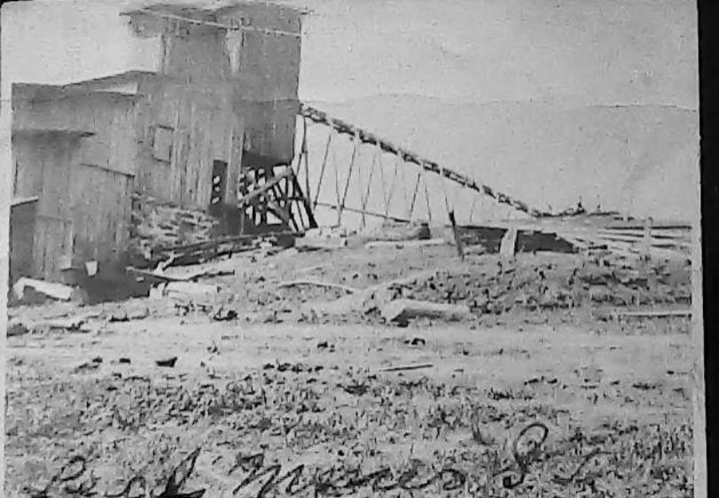
Long before Sugar Grove became known for its quiet farms and mountain vistas, the hills above the South Fork of the Holston River hummed with the sounds of drills, ore carts, and the steady labor of miners chasing veins of lead and zinc. Today, the Rye Valley Mining Company Mine—once called the Chamberlain Mine, the Sugar Mine, and the Sugar Grove Mine—sits silent. But in the late 19th and early 20th centuries, it was the center of a small but determined mining district that stretched from Sugar Grove to Teas and on to Troutdale. Though the industry never reached the scale its early promoters hoped for, the Lead Mines of Rye Valley left behind a fascinating chapter of local history—one written in dolomite, galena, and the stubborn optimism of the people who worked these rugged hills. The Mine was already known before 1897, when the company formally began production. The earliest workings were simple test pits and shallow trenches dug along a brecciated zone of Early Cambrian dolomite—rock more than 500 million years old. This dolomite, fractured and sugary‑textured, hosted narrow but promising veins of galena (lead ore), sphalerite (zinc ore), and occasional gold. By 1897, the mine was officially in operation. Production was modest—just 30 carloads of hand‑sorted ore left the site in the late 1890s—but the quality of the galena was good enough to attract further investment. Assays from the period reported gold values of $6.50 per ton, a small but intriguing bonus. The mine’s workings extended along a northeast trend on the northern hillside above State Road 675. Two inclined shafts followed the 60‑degree dip of the rock, reaching depths of 100 and 200 feet, and were connected underground by a drift at the 100‑foot level. Later reports from Currier (1935) describe three shafts, two of them 200 feet deep, spaced roughly 100 feet apart. Even in the 1980s, field examinations found the remains of these shafts—caved in, overgrown, and in some cases filled with trash—but still unmistakably the scars of an earlier industrial age. In 1907–1908, the Chamberlain Mineral Company took over operations and erected a 100‑ton mill on the south side of the ridge, just north of State Road 675. The foundations of this mill still survive, a quiet reminder of the company’s ambitions. But despite the investment, production remained minimal. Most of the work during this period focused on development and prospecting rather than shipping ore. Lead remained the primary commodity, with zinc, dolomite, and calcium as secondary products. The ore body itself was irregular—up to 23 feet thick in places, but averaging only about 2 feet. Pyrite was scarce. Fluorite, however, made occasional appearances: Thomas Leonard Watson, one of Virginia’s most important early geologists and the author of the state’s foundational mineral and mining surveys (1905) reported violet fluorite, and collectors found more on the dumps as late as 1988. Ultimately, the mine never reached sustained profitability. By the early 20th century, it was largely abandoned, and no plans for reopening have surfaced since. The Rye Valley Mine was only one piece of a broader mineral belt that threaded through the mountains around Sugar Grove. During the mining boom of the 1890s, prospectors opened dozens of pits, trenches, and shafts across the region, all chasing the same dolomite‑hosted veins. Just southwest of Sugar Grove, the Teas Mine was one of the more promising lead‑zinc prospects. Its ore—galena, sphalerite, and barite—was similar to that of the Rye Valley Mine, and early surveys noted its potential. Like many Appalachian prospects, it never fully developed, but it played an important role in defining the district. Along the Brushy Mountain ridge line, small pits and short adits marked the efforts of prospectors who followed float galena or iron‑stained breccia. These workings rarely produced significant ore, but they reveal how widespread the mineralization was. Barite, used in paints and drilling mud, was mined in small quantities north of the South Fork. These shallow open cuts often overlapped with lead‑zinc zones, showing the complex mineral chemistry of the region. East of Sugar Grove, toward Troutdale, miners opened small lead prospects where galena, sphalerite, and purple fluorite occurred in narrow veins. These sites produced some of the district’s more interesting mineral specimens. Further east, the Troutdale area hosted several small lead prospects that followed the same structural trend running through Sugar Grove. Though none became major producers, they help illustrate the regional scope of the mining boom. Walk the hills north of Sugar Grove and you’ll still find the remnants of this forgotten industry: caved‑in shafts, overgrown trenches, scattered dolomite rubble, fragments of fluorite, barite, and quartz, the stone foundation of the old mill The workings extend roughly 300 feet along a northeast trend, hidden now beneath decades of leaf litter and forest growth. The mine is closed, and no modern development is planned, but its story remains an important part of Rye Valley’s heritage. These mines never transformed Sugar Grove into a major industrial center. Yet they represent a moment when the community’s future seemed tied to the minerals beneath its feet—a time when men followed the dip of the rock deep into the hillside, believing that prosperity lay just a few more feet ahead. Today, the Lead Mines of Rye Valley stand as a testament to that era: a blend of geology, ambition, and Appalachian perseverance carved into the mountains themselves. Photos in this article contributed from the Sena Roberts-Ward Collection
